
Buckeye ZIP Areas at a Glance
Two verified postal areas anchor the Buckeye ZIP code directory. The traditional code serves the historic core and a broad central and southern delivery area. The later code serves northern and northeastern growth, including the Verrado area. Both use Buckeye postal identity, but neither line should be treated as the incorporated city boundary. USPS should verify each deliverable address, and county parcel data should confirm the physical site.
| ZIP | Buckeye area served | Postal point | Local record note |
|---|---|---|---|
| 85326 | Historic core plus broad central and southern delivery area | Main Buckeye post office; verify each address | Traditional Buckeye code; postal reach can extend beyond the city line |
| 85396 | Northern and northeastern growth, including Verrado area | Buckeye postal identity; verify each address | Created from part of 85326 effective July 1, 2005; not a municipal boundary |
The main Buckeye post office is at 51 E. Monroe Avenue, Buckeye, AZ 85326-9998, with telephone 623-386-3117. It offers PO boxes and general delivery. Published retail hours are 8:30 a.m. to 4:30 p.m. Monday through Friday and 8:30 a.m. to 12:30 p.m. Saturday. No authoritative source in the Buckeye research established a separate 85396 retail station or another Buckeye-named ZIP, so nearby place codes should not be added without address-level USPS proof.
Buckeye ZIP 85396 Begins
USPS created 85396 from part of 85326 on July 1, 2005. That date provides a useful record-search break. Material from before the split may file a northern Buckeye address under 85326, while later parcel, permit, directory, or correspondence data may use 85396. The street and legal description may remain the same even when the postal code changes.
The official USPS Postal Bulletin notice records the change.
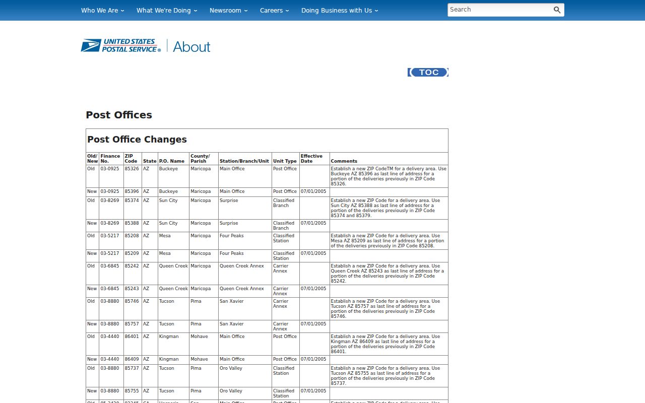
The notice makes the split date a verified fact, not a guess drawn from a modern ZIP map. It also helps explain why one site can appear under different postal codes across dated sources.
Note: Search both 85326 and 85396 when a northern Buckeye address spans records from before and after July 2005.
Find Buckeye Records by ZIP
A ZIP-wide search begins with official postal verification, then shifts to property geography. The USPS ZIP Code Lookup confirms the delivery code for an exact address. Maricopa Parcel Viewer accepts ZIP Code as a “What I Know” search. The Assessor parcel layer distinguishes physical ZIP from mailing ZIP and adds APN, subdivision, MCR, legal geography, owner, deed, construction, zoning, and jurisdiction fields. Those links are far more precise than a postal list alone.
- Enter the complete deliverable address in USPS Lookup. Save the standardized postal result.
- Run that ZIP in Maricopa Parcel Viewer. Narrow the map to the Buckeye area or subdivision of interest.
- Open individual parcel features and save the physical ZIP, APN, situs address, subdivision, MCR, and jurisdiction.
- Compare the Assessor record with Buckeye annexation and community-plan maps to determine city status.
- Once the area is narrowed, use the Buckeye street directory for address, parcel, deed, and permit details.
Do not use Arizona voter data as an open ZIP roster. The state portal serves individual voters, while A.R.S. §16-168 limits broader list purposes and Internet redistribution. A postal code narrows geography. It does not authorize access to restricted data or prove current residence.
Verify a Buckeye ZIP Code
USPS offers address-to-ZIP and city-by-ZIP paths. Use address-to-ZIP for one site because it tests a deliverable address rather than relying on a broad place label. Preserve the standardized street wording returned by USPS. It can resolve a typo before a county search begins, though the postal result still says nothing about title, ownership, or municipal jurisdiction.
The official USPS lookup interface is shown below.
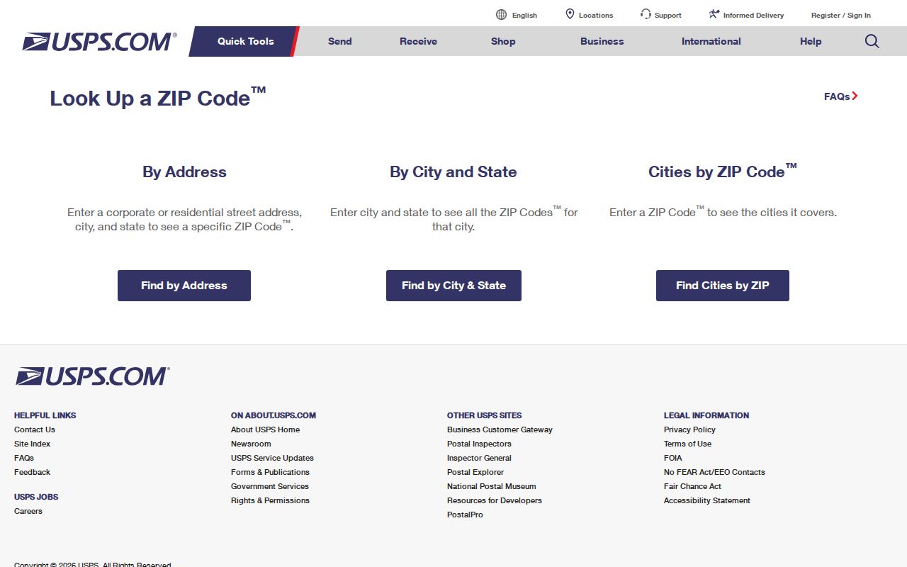
The captured lookup is the right source for delivery coding. Parcel and city records should answer land and jurisdiction questions instead.
A city-by-ZIP result is best treated as a label check. USPS's official labeling pairs 85326 and 85396 with Buckeye, Arizona. It does not create a complete list of sites inside Buckeye city limits.
Buckeye ZIP Search in Parcel Viewer
The Parcel Viewer search help documents ZIP Code among the available “What I Know” choices. It also supports APN, owner, subdivision name, subdivision number or MCR, section-township-range, township and range, Map ID, and personal-property account. Map tools can select by point, line, extent, circle, polygon, or freehand polygon. Results may be added to or removed from a current set.
| Viewer field or tool | Input type | Use after ZIP selection |
|---|---|---|
| ZIP Code | Postal code | Start with all matching parcel features |
| Subdivision Name or MCR | Recorded name or map number | Narrow a large postal area to a planned community |
| APN | Parcel identifier | Open one exact site after map review |
| Polygon, extent, or circle | Map shape | Limit the result to a small geographic section |
| Add or remove selection | Result-set action | Refine a street, block, or community |
A selected set stops at 1,000 features. The cap matters in geographically large Buckeye. Divide a broad area by subdivision or drawn shape, then inspect each feature. The official help screen illustrates this ZIP-capable search.
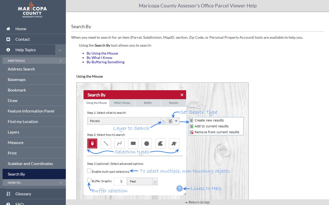
The screen confirms that the ZIP filter is a parcel starting point, not an export of everyone linked to the area.
Buckeye ZIPs Versus City Limits
Buckeye's incorporated boundary is large and irregular. A Buckeye postal label can cover land outside the city, while visually continuous development may cross city, county, school, voting, police, fire, or community-facilities lines. The Buckeye GIS and map gallery supplies annexation, street, council, voting, police, service-area, and approved community master-plan maps. Those layers identify government jurisdiction more reliably than the ZIP code directory.
Address assignment also depends on which government has authority. Buckeye Development Services and GIS manage incorporated-project addressing, while county agencies handle relevant unincorporated land. City GIS folders include Address Data Management, Addressing Reference, Cadastral, Development Services, and Locators. If a street name or number is disputed, request the source address-point or change record. No verified Buckeye-wide renumbering chronology was located.
Portal failure does not end the search. The Assessor accepts an online inquiry and provides counter or telephone help for parcel questions. Buckeye Public Records can route a precise request for an address-point, annexation, or city map record. USPS handles delivery coding, while county and city offices handle land and boundary evidence. Asking each custodian for the record it actually keeps prevents one postal fact from being stretched too far.
Boundary check. Confirm postal delivery with USPS, physical parcel geography with the Assessor, and municipal status with Buckeye annexation maps.
Buckeye Mailing and Physical ZIPs
A parcel record may contain two different codes. The physical ZIP belongs to the site's postal address. The mailing ZIP belongs to the address where the titled owner receives correspondence and can be elsewhere in Arizona or another state. Mixing them can place the wrong person or parcel inside a Buckeye ZIP search. Keep the labels attached to their original fields.
Neither code is the legal description. The APN follows county book-map-parcel and split logic. A subdivision MCR, lot and block, or section-township-range connects the postal address to a recorded map and deed. In master-planned Buckeye areas such as Verrado, Sundance, Tartesso, Festival or Sun City Festival, and Blue Horizons, the recorded subdivision name can narrow a search better than the ZIP alone.
- ZIP and ZIP+4
- ZIP identifies a delivery area; the added four digits narrow delivery within it.
- PO-box ZIP
- A code assigned for post-office boxes rather than general street delivery.
- Unique ZIP
- A code assigned to one organization or high-volume recipient.
- Carrier route
- A postal delivery path within a ZIP, not a city or parcel boundary.
Buckeye ZIP Records by Growth Era
The two verified postal areas often point toward different source strengths. Historic downtown and the broad 85326 area are more likely to connect with older telephone books, school and agricultural material, local newspapers, and regional directories. The newer 85396 and Verrado growth area is better covered by modern assessor records, subdivision plats, permits, association public contacts, and digital deed filings. These are research tendencies, not proof about any one address.
Buckeye's population and land scale explain why one ZIP search can be too broad. Census QuickFacts reports a 2024 estimate of 114,334 residents, compared with 91,502 in 2020 and 50,876 in 2010. The city's 2020 land area was 392.98 square miles. Rapid growth creates new subdivisions and records, while annexation creates a municipal geography that postal codes do not mirror.
Older Buckeye research may also need a place-name check. The settlement was platted as Sidney in 1888, standardized as Buckeye in 1910, and incorporated in 1929. A postal or newspaper reference from an early year may therefore sit under a county or territorial record rather than a city file. Modern codes cannot be projected backward across those changes. Use the date on the source, then test the name and government that existed at that time.
Use the Buckeye ZIP code directory as the first slice. Then switch to subdivision, street, APN, MCR, and exact address. The strongest result preserves each geography instead of treating ZIP, community name, and city limit as interchangeable.
Note: An unverified online ZIP list should never replace USPS address lookup and official Buckeye or Maricopa geographic records.